The Map Panel
The Map panel has options for controlling the Map's properties.
The following properties are on the Map panel:
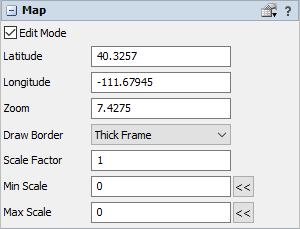
Edit Mode
Edit Mode enables the map to be panned and zoomed in the 3D view. If cleared, then dragging the map tile textures will pan the view instead of the map.
This only affects the map tile textures. The border of the map is not affected by this property. Neither are points, routes, or travelers drawn by the map. Use the Protected flag on points to prevent them from being moved.
Latitude
This number defines the latitude of the center of the map.
Longitude
This number defines the longitude of the center of the map.
Zoom
This number defines the zoom level of the map. Higher numbers are zoomed in.
Draw Border
This number defines how the border is drawn. If no border is drawn, the map can still be selected by clicking an edge.
The size of the thick frame border is based on the Z size of the map. The scale of tile textures is also affected by the map's size. If you want to adjust the relative size of the thick frame border, first change the Z size of the map object and then adjust the zoom back to the desired level.
Scale Factor
This number defines an additional custom scale factor to be used when drawing traveler and point shapes. The zoom level of the view, map size, object size, and model units are also used to scale the size of traveler and point shapes.
Min Scale
This number defines the minimum scale value at which traveler and point shapes will stop being scaled down as the view is zoomed in.
Specify 0 to not use a minimum scale.
Use the button to get the scale value of the map according to its current zoom level.
Max Scale
This number defines the maximum scale value at which traveler and point shapes will stop being scaled up as the view is zoomed out.
Specify 0 to not use a maximum scale.
Use the button to get the scale value of the map according to its current zoom level.